
Guidelines for submitting articles to Mazarron Murcia
Hello, and thank you for choosing Mazarron Murcia to publicise your organisation’s info or event.
Mazarron Murcia is a website set up by Murcia Today specifically for residents of the urbanisation in Southwest Murcia, providing news and information on what’s happening in the local area, which is the largest English-speaking expat area in the Region of Murcia.
When submitting text to be included on Mazarron Murcia, please abide by the following guidelines so we can upload your article as swiftly as possible:
Send an email to editor@spaintodayonline.com or contact@murciatoday.com
Attach the information in a Word Document or Google Doc
Include all relevant points, including:
Who is the organisation running the event?
Where is it happening?
When?
How much does it cost?
Is it necessary to book beforehand, or can people just show up on the day?
…but try not to exceed 300 words
Also attach a photo to illustrate your article, no more than 100kb

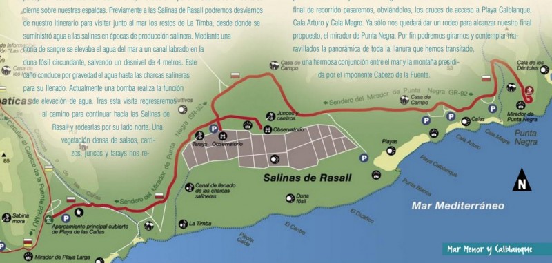
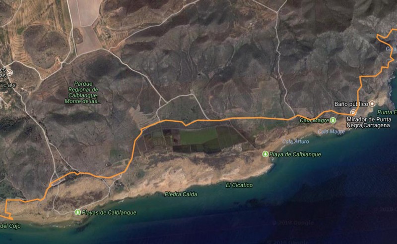
3.85km walk to Punta Negra from Playa de las Cañas in the regional park of Calblanque
A 3.85-kilometre stretch of the GR-92 walk on the coastal plain of the eastern Cartagena coastline
Sendero del Mirador de Punta Negra.
Distance: 3.85km, lineal walk.
This gentle walking route on an unspoilt stretch of the Cartagena coastline in the regional park of Calblanque follows a part of the major GR-92 route, and offers views out over spectacular cliffs which stand like sentinels watching over the Mediterranean. At the same time, such diverse landscapes as marshes, dunes, old crop fields and salt flats are also featured along its nearly 4 kilometres, which at a brisk pace should take just under an hour to cover.
The route includes just 35 metres of climbs and 15 metres of descent, and starts at the car park behind the Playa de Las Cañas. From here it heads east, following the red and white markings of the GR-92 past a small arboretum to a flight of steps which lead into the Rambla de Las Cobaticas, or Rambla de Las Cañas.

Head down the Rambla for a few metres and then turn left on the path towards the salt flats: at this point the landscape is dominated by the silhouette of the Cerro del Atalayón in front of you, while behind stands the hill of Cabezo de la Fuente.
Before reaching the salt flats it’s worth taking a small detour to the remains which can be found in La Timba, as it was from here that water was supplied to the salt flats in the past. Water was lifted from the sea to a height of 4 metres by means of a wheel, and was then transported to the flats along a canal which was dug into the fossil dune, and by this means the flats were filled with salty water. Nowadays the same function is performed by a pump.
Back onto the route, the path skirts the northern inland side of the Rasall salt flats through thick vegetation, including salsola, rushes, tamarisks and reed grasses, before reaching the ornithological observation points next to the flats. If the pool next to the first observation point is not full of water, it is possible to reach the second one, which is slightly further to the east.
Among the nesting birds which can be seen here are the stilt and the common shelduck, and during the winter there are also avocets and Audouin’s gulls.
The path then continues around the salt flats, alongside grassy areas where tall palm trees grow, and past old abandoned rural properties which remain from the days when this area was for more productive in agricultural terms: in fact, some terraces which were used for non-irrigated farming still remain.
This is now the final stretch of the walk, and after crossing the paths which lead down to the coast and Playa Calblanque, Cala Arturo and Cala Magre, the last port of call is viewing point at Punta Negra. Here at long last it is possible to look back over the whole of the flat coastal plain which lies between the Mediterranean and the imposing mountain of Cabezo de la Fuente.
This walk is located inside the regional park of Calblanque, and is easily accessed from the RM-12 dual carriageway which leads from Cartagena to Cabo de Palos and La Manga del Mar Menor.
Click for the Las Cobaticas Visitor Centre in the Calblanque Regional Park from which information can be obtained and leaflets collected.
Recommendations and rules:
1. The Nature Trails Network of the Region of Murcia passes through areas of natural value which must be preserved for future generations: respect for the environment helps everyone to enjoy it.
2. It is highly recommended that walkers be equipped with appropriate shoes and clothes according to the season of the year, and check the weather forecast before departure.
3. High temperatures and strong sunshine are very frequent during the summer in the Region of Murcia, so carry drinking water and wear a cap, sunscreen and sunglasses at this time of year.
4. The information and signs along the trail do not exempt you from any responsibility related to orientation problems encountered in the natural areas; it is highly recommended that walkers carry a map of the area, as well as a compass and/or GPS unit.
5. The upkeep of signs and facilities contributes to the security and joy of trail users. In case of deterioration, loss or any other enquiry please contact the Forest Guards, the Natural Protected Areas staff or the Dirección General del Medio Natural.
6. Please evaluate the information about duration and difficulty of the trail in order to adapt it to your physical capability and experience. Difficulty levels (M.I.D.E. System) have been set for the very best seasons, and the risk of using the trails is low but they can never be entirely risk-free.
7. The duration of each route itinerary is expressed as steady walking, without including rest time and stops. Include extra time for the hike if stops are planned along the way.
8. Walkers should keep the paths and environment clean by keeping with them all litter generated during the walk and placing it in the nearest bins.
9. The lighting of fires is not allowed under any circumstances, except in the seasons and sites equipped for this purpose. Please remember forest fires are one of the worst enemies of our Natural Protected Areas.
10. Please do not collect plants or disturb wild fauna. The use of binoculars and cameras will help you to enjoy and keep the images nature offers.
11. It is highly recommended that you remain within the limits of the marked paths at all times. Some trails also pass through private property: please respect those who live in natural areas and their way of life.
12. It is possible that part of the hiking trails may include forest roads or tracks suitable for motor vehicles. In this case, please walk along the left edge of the path; and, if you are in a group, preferably in single file.
13. In case of emergency, please call the Emergency Phone Number 112.
Click for full pdf in Spanish showing walks in the Calblanque area.

Join the Murcia What's On and Where to Go group on Facebook to keep up to date with all the latest events taking place near you: https://www.facebook.com/groups/MurciaWhatsOnAndWhereToGo/


